
Go back to about 185 years ago! When the first attempts to start photography began. With the development of photography, we saw the photography of balloons, 165 years ago! Certainly, no one was familiar with the concept of remote sensing at that time, but it can be said that the first remote sensing was started in 1860 through balloon photography. With the passing of decades and human discoveries, we witnessed the development, growth and revolution of remote sensing. Theory of electromagnetic spectrum by Maxwell (1873), World War I and aerial reconnaissance (1916), development of radar (1935), World War II and non-visible part of the electromagnetic spectrum (1940), first space photograph of the earth (explorer-6; 1959) and so on. These are the milestones of the birth of remote sensing that finally in 1972 Landsat-1 (ERTS-1; MSS sensor) was launched: the beginning of passive remote sensing as you see it in today's world (Campbell and Wynne, 2011). Perhaps the question that comes to your mind is what is passive remote sensing? Stay with us to answer it in this article.
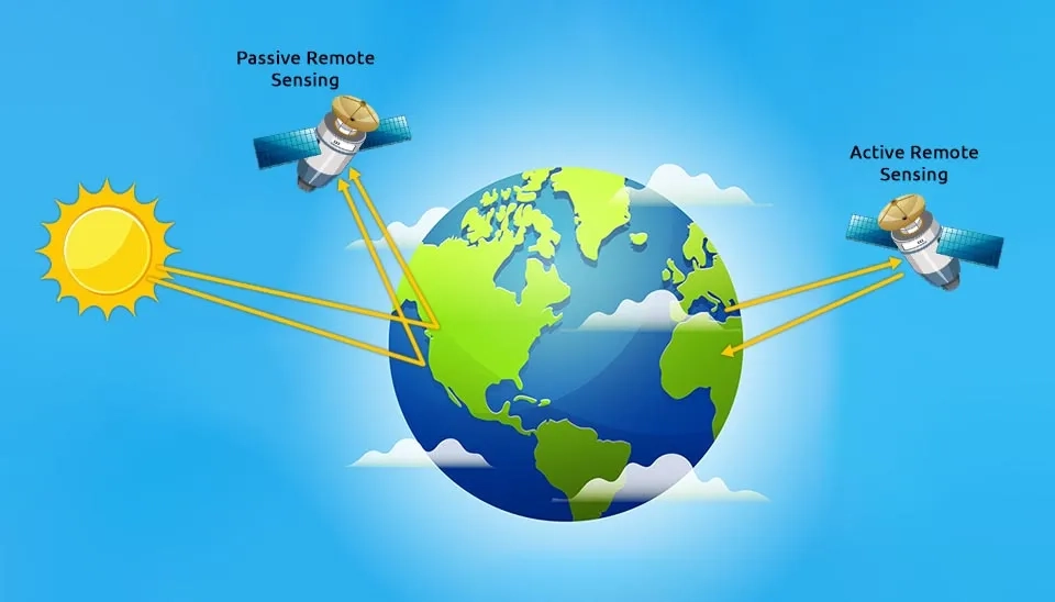
Table 1. Satellites with passive remote sensing sensors, their spatial resolution, temporal resolution, and time coverage (Chawla et al., 2020)
Satellite | Sensor | Time Coverage | Spatial Resolution | Temporal Resolution |
Optical and Thermal Sensors | ||||
Lansat | Multispectral Scanner System (MSS) | 1972 - present | 57 and 60 meters | 16-18 days |
Thematic Mapper (TM) and Enhanced Thematic Mapper (ETM) | 1972 - present | 30 and 120 meters | 16 days | |
Geostationary Operational Environmental Satellites (GOES) | GOES Imager | 1975 - present | 1 and 4 kilometers | - |
Satellite pour l'Observation de la Terre (SPOT) | High Resolution Visible (HRV) | 1986 - 2009 | 20 meters | 26 days |
High Resolution Visible and Infrared (HRVIR) | 1993 - 2013 | 10 and 20 meters | 26 days | |
Vegetation | 1998 - 2015 | 1 kilometer | 26 days | |
NIMBUS-7 | Coastal Zone Color Scanner (CZCS) | 1978 - 1995 | 825 meters | 6 days |
Indian Remote Sensing (IRS) | Linear Imaging Self-Scanning System I (LISS-I) | 1988 - 2003 | 72.5 meters | 22 days |
Linear Imaging Self-Scanning System II (LISS-II) | 1991 - 2003 | 36.25 meters | 22 days | |
Linear Imaging Self-Scanning System III (LISS-III) | 1995 - 2010 | 5.8, 23.5, and 70.5 meters | 25 days | |
Japan Earth Resources Satellite (JERS-1) | Optical Sensor (OPS) | 1992 - 1998 | 18.3 and 24.2 meters | 44 days |
OrbView-2 | Sea-viewing Wide Field Sensor (SeaWiFS) | 1997 – 2010 | 1.1 and 4.5 kilometers | 1 day |
IKONOS | Multispectral and Panchromatic Sensor | 1999 - 2015 | 0.82 and 3.2 meters | 3 days |
Terra | Advanced Spaceborne Thermal Emission and Reflection Radiometer (ASTER) | 1999 – present | 15,30, 90 meters | 16 days |
Terra, Aqua | Moderate Resolution Imaging Spectroradiometer (MODIS) | 2000 – present | 250, 500, and 1000 meters | 16 days |
Earth Observatory-1 | Hyperion | 2000 - 2017 | 30 meters | 16 days |
Advanced Land Imager (ALI) | 2001 - 2017 | 10 and 30 meters | 16 days | |
QuickBird | Multispectral and Panchromatic Sensor | 2001- 2015 | 0.65 and 2.62 meters | 1 – 3.5 days |
ENVISAT | Medium Resolution Imaging Spectrometer Instrument (MERIS) | 2002 – 2012 | 300 and 1200 meters | 35 days |
Ice, Cloud, and land Elevation Satellite (ICESat) | Geoscience Laser Altimeter System (GLAS) | 2003 – 2010 | 65 meters | 91 days |
Advanced Topographic Laser Altimeter System (ATLAS) | 2018 – present | Less than 17.5 meters | 91 days | |
WorldView 1/2/3/4 | Panchromatic, multispectral, SWIR sensors | 2007 – present | 0.31, 1.24, 3.7 meters | Less than 1 day |
National Oceanic and Atmospheric Administration' s (NOAA's) Polar Orbiting Environmental Satellites (POES) | Advanced Very High-Resolution Radiometer (AVHRR) | 2009 and 2012 – present | 1.1 and 4 kilometers | 1 day |
NOAA-20 | Visible Infrared Imaging Radiometer Suite (VIIRS) | 2011- present | 375 and 750 meters | 16 days |
Ziyuan | Multispectral Camera | 2012 – present | 5.8 meters | 4-5 days |
RapidEye | Multi-spectral imager | 2008 – present | 6.5 meters | 1 day |
Sentinel 2A and 2B | Multi-Spectral Imager (MSI) | 2015 and 2017 – present | 10, 20, and 60 meters | 5 days |
Passive Microwave Sensors | ||||
Aqua | Advanced Microwave Scanning Radiometer-Earth Observing System (EOS) (AMSR-E) | 2002 - 2011 | 5.4 - 56 kilometers | 1 - 2 days |
Microwave Imaging Radiometer using Aperture Synthesis (MIRAS) | Soil Moisture Ocean Salinity (SMOS) L-band radiometer | 2010 – present | Less than 50 kilometers | 2.5 - 3 days |
GCOM-W | Advanced Microwave Scanning Radiometer 2 (AMSR2) | 2012 – present | 3 - 62 kilometers | 1 - 2 days |
Soil Moisture Active Passive (SMAP) | SMAP L-band radiometer | 2015 – present | 47 and 39 kilometers | 1 - 3 days |
Passive remote sensing is used as a branch of remote sensing in various studies. One of the applications of passive remote sensing is in water science studies and water resources management. Many studies have investigated the applications of remote sensing in rainfall estimation, evaluation of snow and ice cover, and soil moisture measurement (Rango, 1993). Passive remote sensing applications include quantitative water studies such as urban studies, hydrological modeling, and hydrological processes (such as potential evapotranspiration) and qualitative water studies, which help to improve the analysis and modeling of water resources. However, passive sensors face challenges and limitations that are expected to be resolved in the future (Melesse, 2007; Haji Gholizadeh et al., 2016).
1. What is Passive Remote Sensing? (Mechanism of Passive Remote Sensing)
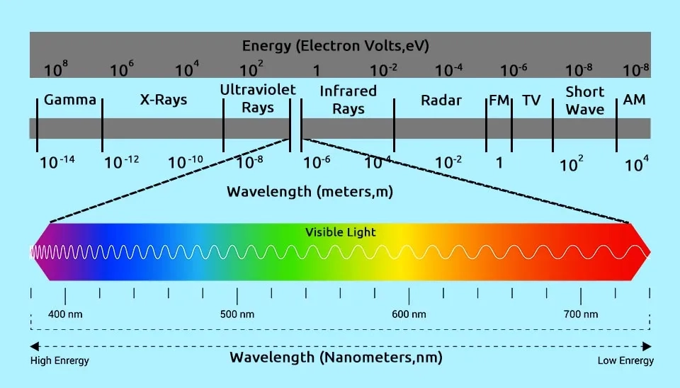
Sensors in remote sensing collect and analyze the energy reflected from the ground. The response of the earth and the objects on it to the received energy and its reflection is determined through the reflected optical signature, which can be distinguished for each object like human fingerprints. Reflectance signatures, also known as spectral signatures or reflectance spectra, are divided into five categories: spectral, spatial, angular, temporal, and polarization signatures. Reflectance signatures include the spectral response of objects to multiple spectral bands and wavelengths, which indicate the amount of absorption or reflection of electromagnetic radiation (Gerstl, 2007).
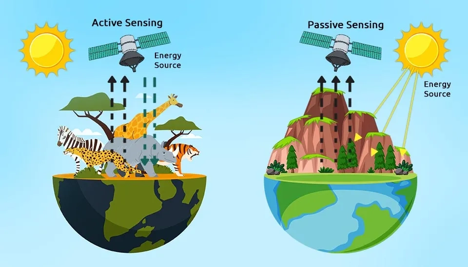
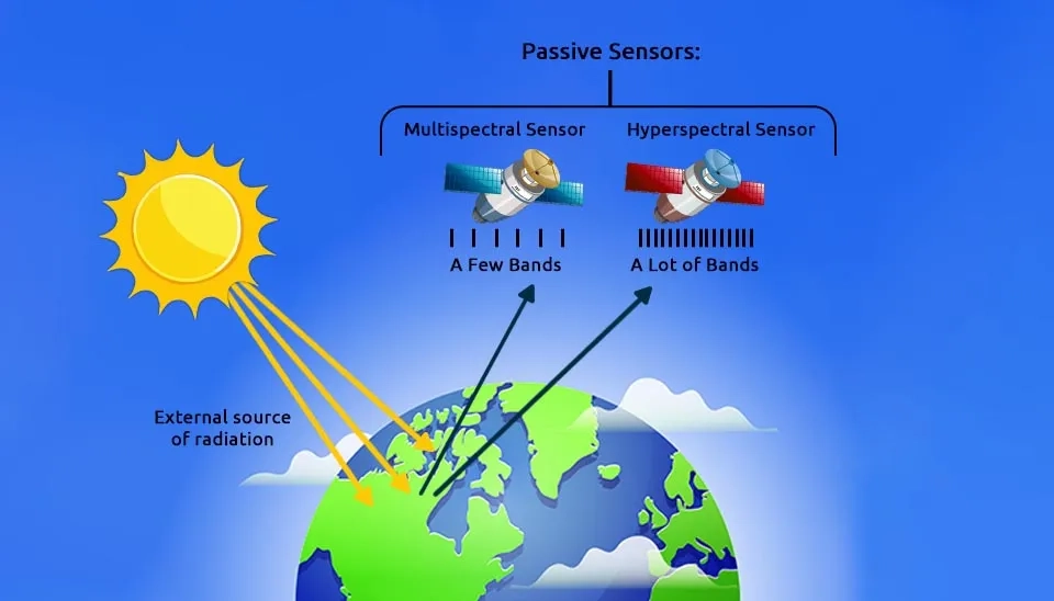
In general, optical sensors in remote sensing are divided into two categories based on the source of electromagnetic radiation supply: Active and passive optical sensors. Active optical sensors do not require an external source of electromagnetic radiation. Active optical sensors are able to provide the necessary electromagnetic radiation for radiation to the ground and reflection from it. Active optical sensors collect information by emitting their electromagnetic radiation to the ground and analyzing the target's reflectance signature. On the other hand, passive optical sensors are based on solar radiation and do not have an electromagnetic energy source. Relying on solar energy creates challenges for passive optical sensors. Due to the limited solar radiation during the day and its absence at night, passive optical sensors cannot collect data at night. In addition, cloud cover and alternating conditions of electromagnetic radiation of the sun cause noise and variability in the data obtained from passive sensors (Veverka, 2020; Hatfield et al., 2008). Therefore, it is necessary to implement more accurate approaches to check the data of passive sensors.
2. Types of Passive Remote Sensing
In general, passive remote sensing is divided into two categories based on the imaging and scanning mechanisms: 1. scanning passive remote sensing sensors; and 2. non-scanning passive remote sensing sensors, which are explained below.
2.1. Scanning Passive Remote Sensing Sensors
Remote sensing sensors based on scanning collect and analyze data through imaging and scanning the surface of the earth or atmosphere. Remote sensing sensors are divided into two categories: Image plane scanning and Object plane scanning. Sensors based on image plane scanning continuously scan the earth's surface perpendicular to the satellite's flight path and collect data. By recording a wide range of images, these sensors are used in satellite systems with high spatial resolution. On the other hand, object plane scanning scans the surface of the earth by moving a sensor system or mirror in the field of view. Compared to image plane scanning, object plane scanning performs scanning in narrower bands and is used in airborne remote sensing (Schlarp et al., 2020).
-67fa99690371478f4d8b0474)
2.2 Non-scanning Passive Remote Sensing Sensors
As their name suggests, non-scanning sensors do not require scanning and are divided into two categories: imaging and non-imaging. Passive imaging sensors record the reflected radiation in the visible and near-infrared spectrum and produce two or three-dimensional images. Digital cameras and the human eye are examples of passive imaging sensors. Passive non-imaging sensors such as microwave radiometers measure the thermal radiation emitted from the earth's surface at microwave frequencies and are used in studies of the earth's atmosphere, weather, and temperature (Imaoka et al., 2000).
3. Components of Passive Remote Sensing Sensors
Passive remote sensing generally uses two techniques, multispectral and hyperspectral imaging, to analyze electromagnetic radiation (Han and Kerekes, 2017). Multispectral imaging uses a limited number of spectra to extract ground information and has a relatively low spectral resolution, however, it can cover a more general view of the surface of the earth. Examples of multispectral imaging based on passive sensors include the Landsat series and Sentinel-2. In contrast, Hyperspectral imaging uses multiple and continuous spectral bands; It has a higher spectral resolution and provides more accurate information. Hyperion onboard the EO-1 satellite and the EnMAP satellite mission are among the hyperspectral imaging instruments (Adam et al., 2010).
Passive remote sensors include radiometers and spectrometers. Components of passive remote sensing are described below (Eath Data):
1. Accelerometer: The accelerometer has the task of measuring acceleration. Acceleration consists of two components: translational acceleration, which is the change of speed per unit of time in the direction of linear motion, and angular acceleration, which is the change of rotational speed per unit of time. Accelerometers are divided into two categories based on the type of acceleration measured (translational acceleration or angular acceleration).
2. Hyperspectral radiometer: Hyperspectral radiometers are capable of detecting several narrow spectral bands in the infrared, near-infrared, and visible ranges of the electromagnetic spectrum. Hyperspectral radiometer has a high spectral resolution and can be accurately identified based on the spectral response of objects in each of the bands, considering an advanced multispectral sensor.
3. Imaging radiometer: The imaging radiometer combines imaging and radiometry, providing spatial information by measuring the intensity of electromagnetic radiation in specific spectrum bands. Scanning can be done mechanically or electronically using detection equipment.
4. Radiometer: Radiometers are responsible for measuring the intensity of electromagnetic radiation in specific bands. The measured electromagnetic bands are part of the spectrum that the radiometer covers, such as the infrared, near-infrared, and visible ranges.
5. Sounder: The sounder captures the vertical distribution of atmospheric parameters such as temperature, humidity, pressure, and gas compositions using multispectral information. The sounder is used in meteorological studies, meteorology, and weather forecasting.
6. Spectrometer: A spectrometer, using gratings or prisms, analyzes incident electromagnetic radiation and extracts information related to the spectrum.
7. Spectroradiometer: A spectroradiometer analyzes and extracts geophysical information by measuring radiation intensity in multi-spectral bands at high spectral resolution.
4. Conclusion
A branch of remote sensing that has attracted the attention of researchers in recent years is passive remote sensing, which is used in water science and its management (quantitative and qualitative studies of water resources). Unlike active remote sensing, passive remote sensing does not have a source of electromagnetic radiation and uses sunlight and the reflection signature of objects to collect information. Using sunlight causes challenges and limitations for passive remote sensing, such as inefficiency at night, noise, and high variability. Passive remote sensing includes accelerometers, radiometers, sounders, imaging radiometers, hyperspectral radiometers, spectrometers, and spectroradiometers. Based on the imaging and scanning mechanisms, passive remote sensing sensors are divided into two categories: scanning sensors ( image plane scanning and object plane scanning) and non-scanning sensors (imaging and non-imaging), Each category has different applications and features. By examining the types and categories of passive sensors, this article can help to further understand the capacity of passive remote sensing in many studies.